|
|
Post by tenochtitlanuk on Apr 14, 2024 12:07:19 GMT -5
Sorry- only now posting latest version with all projections working. If you run it, I suggest you view the Help file while it completes the default initial map. File at forNow2.zip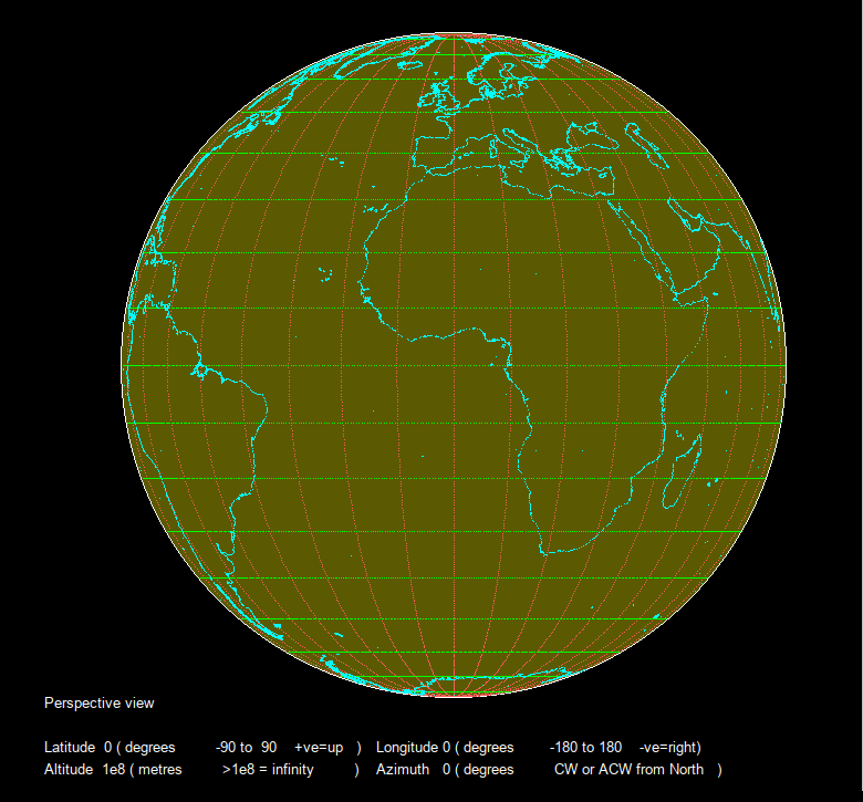 |
|
|
|
Post by tenochtitlanuk on Apr 6, 2024 4:21:55 GMT -5
Fun- and a bit scary for me as I hit 78 in a few days. As a UK male, statistics say 50% of my age group will be dead within six years. So fingers crossed against bad luck!! The behaviour of populations tends to be shown with 'population pyramids' of a whole country- or the world. These show numbers, male and female, in 'age cohorts'. You build in the present ( ie known) fertility and death rates and let the model rip. If you think you know how rates may change in future ( eg birth rates drop rapidly as Third World countries develop) you can include that. And then throw in unpredictable catastrophes like wars and epidemics. Bit like playing God, really! 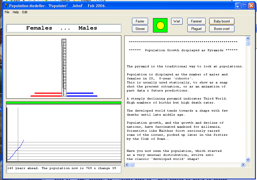 You can find my LB stuff on this at Population pyramids about half way down the examples. In a teaching environment it was fun to get pupils to try to manipulate rates etc to get a stable population! It is essentially impossible- it will either crash down or soar up! We NEED war, famine, pestilence, meteor strikes, gods.... NOT! Lucky we have brains and can model ahead and plan interventions. |
|
|
|
Post by tenochtitlanuk on Apr 6, 2024 4:00:27 GMT -5
Hi Mike
Welcome( back)
I agree entirely on LB's ease of use and utility especially in applications involving interfacing to hardware.
I look forward to more details of the plasma cutter interface. It's something I've been very tempted to play with.
|
|
|
|
Post by tenochtitlanuk on Apr 3, 2024 8:43:58 GMT -5
There are indeed lots of free GIS databases around. Getting the data out in a form that LB can handle is a pain however. Natural disasters could be fun. Topography ( including ocean depths) too.
I wonder if I can download aircraft tracking data and show it 'on the globe'? It would show clearly the need for 'great circle' routes...
tsh73 ( Anatoly) seems to have implemented the Mouse position to Lat/Lon and worked on joining dots for coast if they are very close, and/or for the lat/lon grid.
Fun fun fun...
|
|
|
|
Post by tenochtitlanuk on Apr 3, 2024 4:32:37 GMT -5
Thanks Anatoly for the feedback. Will adapt my next version! As you can see from my code I probably should have coded from zero rather than forcing old code to suit my modern tastes!
EDIT I've mod'd so my version chooses smaller steps when you are at low altitudes- avoids 'joining the dots' line method and its problems!
Honky- I'll try to code the reverse action of clicking on a projection and displaying the relevant Lat/Lon pair. It's all still a work in progress.
If anyone finds other usable global databases of lat/long data with other associated things, like altitude or land use, let me know.
|
|
|
|
Post by tenochtitlanuk on Apr 2, 2024 15:16:24 GMT -5
See link to zip file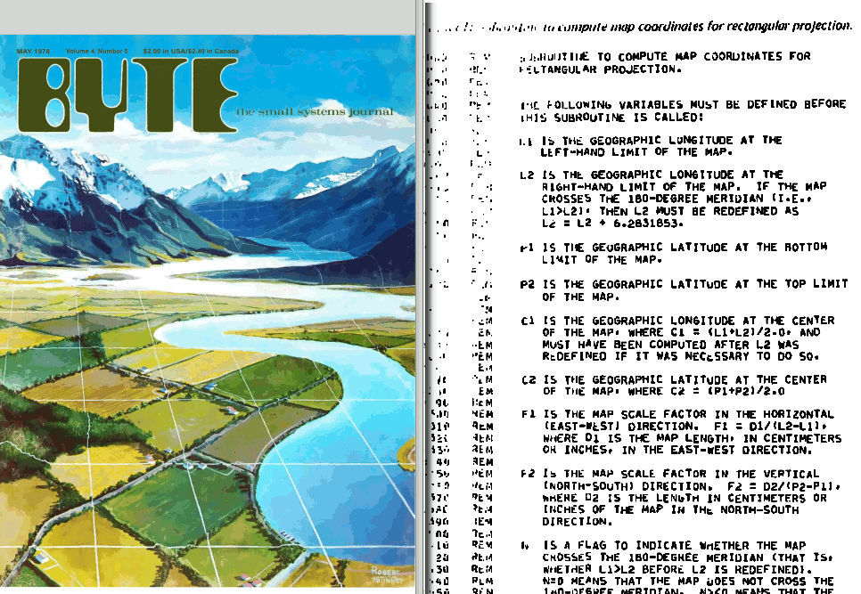 To be fair, most of the scanned BYTE pages were better than this one! Will do full page too on my web site asap. . . with some scans to show how much work this took! |
|
|
|
Post by tenochtitlanuk on Apr 1, 2024 9:55:41 GMT -5
Fairly happy now... watch the Earth's heartbeat! 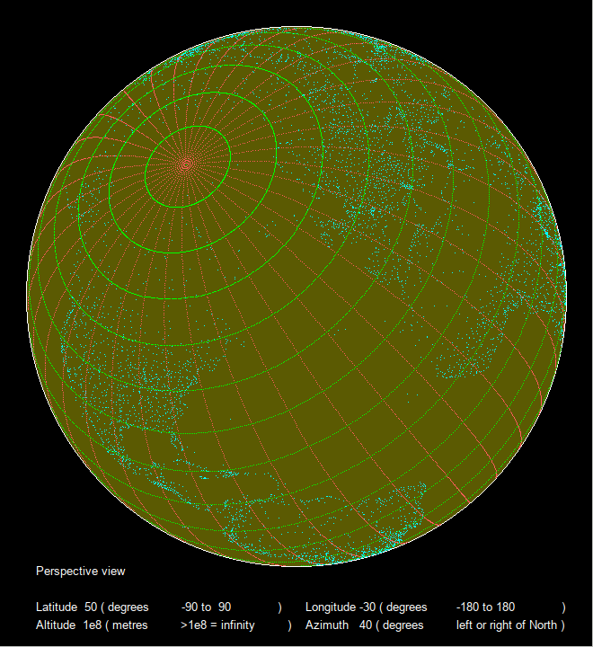 |
|
|
|
Post by tenochtitlanuk on Mar 30, 2024 16:56:14 GMT -5
Looks worth a try. I'll add to my list of things to try!
|
|
|
|
Post by tenochtitlanuk on Mar 30, 2024 6:01:15 GMT -5
Current version and the new database will be on my site in a few days.
It's a fun area with lots of possibilities.
Bit busy over Easter...
|
|
|
|
Post by tenochtitlanuk on Mar 29, 2024 17:42:09 GMT -5
Anatoly- sadly the database mixes point data and data corresponding to feature boundaries, in sections, but all unseparable in the csv file since there id no 'end of section' marker. So no way to know when you are moving to a new section, and need to lift the pen and then lower for the new section. Result is a whole lot of incorrect joining lines...
Vector file formats are available that cover this but they are hard to decipher- you can load them into a GIS like the ( free) QGIS, but the kind of customised projections I am interested in are not catered for there.
Similarly, the lat/longitude would be better shown with points connected by straight lines, but this gives problems at the boundaries. But I may implement a method of plotting close together dots between the existing spaced dots.
The 'zoom view' DOES have a round boundary. Think looking down on Baikonur from 100km, or down from a Starship return-landing approach. The horizon is equidistant in all directions. It's not the same as enlarging a section of the 'view from infinity'.
|
|
|
|
Post by tenochtitlanuk on Mar 29, 2024 13:43:40 GMT -5
Have added a GUI front end. 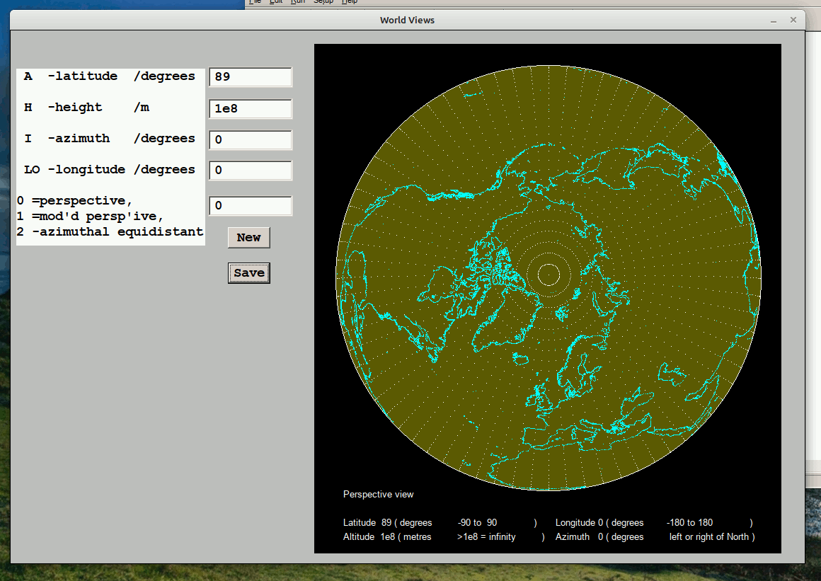 I've also located a database of coastal points- but being 12* bigger it makes processing slower- and when you zoom down you start to realise how BIG our globe is! 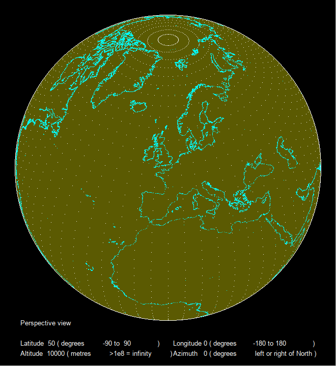 Not finished yet. Several planned alterations /additions. |
|
|
|
Post by tenochtitlanuk on Mar 18, 2024 9:01:51 GMT -5
It's well worth playing to add things to the code. You've some good ideas to give it an interactive GUI front end . . . I'll follow your changes with interest.
Yes, you obviously don't get all the images saved unless you allow a full run first. It's a way to make a suitable speed animation to display, since LB is much slower than other languages.
Do you really have a ( French) font called 'courrier'? I'm only aware of 'Courier'. And if you specify a font for the window #w, all buttons eg #w.b1 pick the chosen font without you having to tell each one- unless you want different sizes.
I did warn that the original BYTE code was wrong in parts. You need to be very clear where you are working in degrees OR radians, and in screen coordinates. It took me ages to sort out in my version.
Haven't time at present to see why your code doesn't work correctly- I'm away from home for a while.
I'll be concentrating on the polar equidistant and orthographic polar projections when I have time. Did you look at the BYTE article? It gives us a base to work on...
J
|
|
|
|
Post by tenochtitlanuk on Mar 16, 2024 15:00:09 GMT -5
Copy/paste this URL directly, and don't click it as a web redirect, for sample code and datafiles in a zip file. www.diga.me.uk/CitySky.zipLinks from the forum add all the other stuff I assume.... 'tho it works fine for my browsers... |
|
|
|
Post by tenochtitlanuk on Mar 16, 2024 7:07:41 GMT -5
After the for/next loop has gone through all the iterations, you will find it has saved all the screens. I use the GIMP to turn these into an animated GIF- you can select the frame time interval, but other software should do the same. Then load the animation in your web-browser. I can supply info on doing this in GIMP if you haven't done animated GIFs before. I do use it a lot!
If you want to run it 'live' continuously, REM out the bmpsave line, and loop/goto the beginning of the Lo loop...
|
|
|
|
Post by tenochtitlanuk on Mar 16, 2024 5:00:27 GMT -5
Thanks honky -Yeah- sorry about the naming. Too many versions I've been playing with!
|
|


